


Reality Capture und
Lösungen für den Zugang zur Realität
Lösungen für den Zugang zur Realität

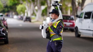
Verwenden Sie NavVis VLX zusammen mit einem beliebigen Vermessungsgerät, das sich bereits in Ihrem Bestand befindet. Für eine Genauigkeit, die den Industriestandard eines jeden tragbaren Geräts übertrifft, NavVis VLX wird von der Präzisionstechnologie SLAM unterstützt, die eine Klasse für sich ist. Unsere Kunden verwenden NavVis Technologie für 90 % ihrer Projekte.

Verarbeiten, georegistrieren und richten Sie automatisch Scandaten von NavVis Geräten mit der Genauigkeit von vermessungstauglich . Generieren Sie fotorealistische Punktwolken und 360°-Panoramen.

Mit NavVis IVIONwerden Punktwolken und Panoramabilder in intelligente Räume umgewandelt, die von jedem Standard-Webbrowser aus zugänglich sind. Erstellen Sie Ihre virtuellen Standorte (digitale Zwillinge), einschließlich Grundrissen und Routing. Arbeiten Sie gemeinsam an Projekten mit einfachem virtuellem Zugang und einfacher Navigation.
Besondere Nachrichten
DIE ROLLE VON TRAGBAREN mobiles Mapping

Besondere Nachrichten
.jpg?width=300&name=NavVis-VLX-3-Culver-Street-linework-517-webinar-advancing-topographic-surveys-events-page-04092024-wp-featured%20(1).jpg)
Kommendes Webinar Fortschrittliche topografische Vermessungen:
Die Rolle von Wearables mobiles Mapping
Kommendes WebinarFortschrittliche topografische Vermessungen:
Die Rolle von Wearables mobiles MappingSichern Sie sich Ihren Platz
Ankündigung NavVis IVION ist jetzt Teil von NVIDIAs Accelerated Apps Catalog
Punktwolkendaten Erhebung über städtische Straßen
E-Book Jenseits der Grenzen: NavVis VLX in der Praxis
Abonnieren Sie den NavVis-Newsletter!
Sie erhalten die neuesten Updates, Nachrichten und Brancheneinblicke.